
Best Hiking Trails Near Missoula: Your Local Guide to the Top Spots |
From the iconic M to hidden Rattlesnake gems — your insider trail guide starts here. |
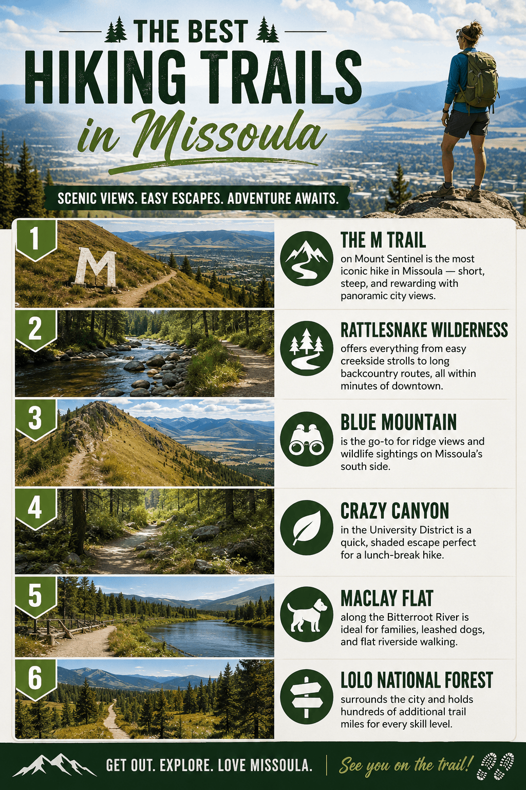
Quick Answer: Best Hiking Trails Near Missoula
Why Missoula Is a Hiker's Dream
Missoula sits in a valley ringed by mountain ranges on nearly every side, which means trailheads start practically at the city limits.
You can be on a forested ridgeline, a river-bottom nature trail, or a wilderness creek drainage in under 20 minutes from downtown — no long drive required.
That accessibility is what sets Missoula apart, and it's why locals treat hiking less like a weekend trip and more like a daily habit.
The M Trail — Missoula's Most Iconic Hike
The M on Mount Sentinel is the trail every Missoula newcomer hikes first — and the one locals never get tired of.
The trail climbs roughly 620 feet in about 0.9 miles to a large concrete letter that has marked the University of Montana hillside for over a century.
Go early on a weekday morning for the best views and the fewest crowds — sunrise from the M looking west over the Clark Fork Valley is genuinely stunning.
From the M you can continue up to the Sentinel Summit for a longer, more demanding out-and-back that rewards you with 360-degree views of four mountain ranges.
Rattlesnake Wilderness — Missoula's Backyard Backcountry
The Rattlesnake National Recreation Area and Wilderness is one of the most remarkable urban-adjacent wild areas in the entire American West.
The main corridor follows Rattlesnake Creek through a cool, shaded canyon — it's popular with trail runners, dog walkers, mountain bikers, and day hikers alike.
Push deeper into the drainage and the crowds thin fast; by the time you hit the wilderness boundary, you may have the trail entirely to yourself.
The Rattlesnake Trailhead parking lot off Rattlesnake Drive is the main access point, and it fills quickly on summer weekends — arrive before 8 a.m. or plan for a short road-side park-and-walk.
Blue Mountain — Ridge Views and Wildlife on the South Side
Blue Mountain Recreation Area is Missoula's best-kept secret for people who want elevation gain, open ridge walking, and real wildlife encounters without driving an hour out of town.
The trail network climbs through ponderosa pine and Douglas fir to open ridgelines where you're likely to spot white-tailed deer, wild turkeys, and the occasional black bear.
Views from the top stretch across the Bitterroot Valley to the south and back toward the Rattlesnake peaks to the north — it's a genuinely different perspective on the city.
Access is from the Blue Mountain Trailhead parking lot off Forest Hill Lane on Missoula's southwest side.
Crazy Canyon and the University District Trails
Crazy Canyon is a shaded, forested drainage that cuts into the hills directly above the University of Montana campus.
It's one of the most convenient trails in Missoula — walkable from the university neighborhood and short enough to complete in under an hour.
The canyon feels surprisingly wild for how close it sits to the heart of the city, with a small seasonal stream, dense tree cover, and almost no road noise once you're inside.
Combine Crazy Canyon with the lower M Trail switchbacks for a satisfying morning loop that covers both shaded canyon and open hillside terrain.
Maclay Flat and River-Bottom Walking
Not every great Missoula hike involves climbing — Maclay Flat Nature Trail proves that flat, river-bottom walking has its own distinct magic.
The trail system winds through cottonwood groves along the Bitterroot River on Missoula's southwest side, making it perfect for families with young kids, older hikers, or anyone who just wants a peaceful outdoor walk.
Leashed dogs are welcome, the trail surface is forgiving underfoot, and the riparian scenery — especially in early June when the cottonwoods are leafing out — is genuinely beautiful.
Managed by the Lolo National Forest, Maclay Flat is accessed off Forest Road 19155 near the Maclay Bridge.
North Loop and Lincoln Hills — A Neighborhood Gem
The North Loop Trail in the Lincoln Hills area on Missoula's north side is a quiet, underused trail that locals in that neighborhood treat as their own private hiking loop.
The terrain is open hillside with views down into the Clark Fork corridor, and the trail rarely sees the weekend crowds that hit the M or Rattlesnake.
If you live on the north side of town or want a crowd-free alternative on a busy Saturday, this is the trail to know.
Seasonal Tips for Hiking Near Missoula
Spring (April–May): Lower elevation trails like Maclay Flat and Crazy Canyon open first — expect mud on north-facing slopes and check for seasonal closures in elk calving areas.
Summer (June–August): Peak season for all trails; start early to beat heat on exposed routes like the M and Blue Mountain, and always carry more water than you think you need.
Fall (September–October): The best hiking season by many locals' measure — cooler temps, fall color in the creek drainages, and noticeably thinner crowds after Labor Day.
Winter (November–March): The M Trail stays hikeable most of the winter; Rattlesnake and Blue Mountain trails can be packed for snowshoeing, though avalanche awareness matters on steeper terrain.
Local Resources: Missoula Hiking Trailheads and Contacts
The M (Mount Sentinel Trail) Missoula, MT 59803 | (406) 721-7275 One of Missoula's most-hiked landmarks, with clear signage and a well-maintained switchback trail up to the iconic concrete letter above campus. Best for: First-time Missoula visitors, University District residents, and anyone wanting a quick high-reward climb with city views.
Rattlesnake Trailhead Parking lot, Missoula, MT 59802 | (406) 329-3750 The main gateway into the Rattlesnake National Recreation Area, with access to creekside trails, wilderness routes, and mountain bike singletrack all from one lot. Best for: Trail runners, dog walkers, families wanting an easy creekside walk, and backpackers heading into the wilderness.
Blue Mountain Trailhead Parking lot, Forest Hill Ln, Missoula, MT 59804 The access point for Blue Mountain Recreation Area's network of ridge trails, with a well-signed lot and room for a reasonable number of vehicles. Best for: Hikers wanting elevation gain, open views, and wildlife sightings without the crowds of more central trails.
Maclay Flat Nature Trail Forest Rd 19155, Missoula, MT 59804 | (406) 329-3814 A flat, accessible nature trail along the Bitterroot River managed by Lolo National Forest, with interpretive signage and a dog-friendly surface. Best for: Families with young children, senior hikers, leashed-dog walks, and anyone who prefers a peaceful flat trail over a climb.
Crazy Canyon Trailhead Missoula, MT 59803 A shaded canyon trail directly above the University of Montana neighborhood — short, accessible, and surprisingly wild-feeling for its location. Best for: University District residents, students, and anyone wanting a quick shaded escape during a busy day.
Barmeyer Trail Trailhead Missoula, MT 59803 A lesser-known trailhead with a strong local rating (4.8 stars) that rewards hikers who prefer discovering trails off the beaten path. Best for: Locals looking for a quieter alternative to the main corridors and hikers who enjoy a bit of trail exploration.
North Loop Trail 3658–3886 Lincoln Hills Dr, Missoula, MT 59802 A north-side neighborhood trail with open hillside terrain and Clark Fork views — one of Missoula's most underrated loops. Best for: North-side residents, hikers wanting a crowd-free weekend option, and those who enjoy open-ridge walking close to home.
Lolo National Forest — Missoula Ranger District 24 Fort Missoula Road, Missoula, MT 59804 | (406) 329-3750 The managing agency for most of the public land surrounding Missoula — the best source for trail conditions, fire closures, and permit information before any outing. Best for: Anyone planning a longer hike, backcountry trip, or needing up-to-date seasonal trail information.
FAQ: Hiking Near Missoula
What are the best hiking trails near Missoula for beginners? The lower M Trail (just to the letter, not the summit), Maclay Flat Nature Trail, and the main Rattlesnake Creek corridor are all beginner-friendly — well-marked, heavily trafficked, and forgiving in terms of distance and terrain.
Are dogs allowed on Missoula hiking trails? Dogs are welcome on most trails, including Maclay Flat, the Rattlesnake corridor, and Blue Mountain, but must be leashed in developed recreation areas and under control at all times — check current Lolo National Forest regulations before heading out, as rules can vary by zone.
How do I find current trail conditions near Missoula? The Lolo National Forest Missoula Ranger District at 24 Fort Missoula Road is the most reliable source — call (406) 329-3750 or check the forest service website for seasonal closures, fire restrictions, and snowpack updates before any outing.
What is the most popular hike in Missoula? The M Trail on Mount Sentinel is almost certainly the single most-hiked trail in Missoula, given its location directly above campus and its reputation as the first hike every new resident completes.
Are there hikes near Missoula with good views? Yes — The M and the Sentinel Summit above it, the ridgelines of Blue Mountain Recreation Area, and the upper North Loop Trail in Lincoln Hills all offer open views of the Missoula valley and surrounding mountain ranges.
Get Outside — Missoula's Trails Are Waiting
Whether you've lived here for decades or just rolled into town, Missoula's trail network is one of the city's defining features and its greatest everyday luxury.
Start with the classics — the M, the Rattlesnake, Blue Mountain — then let curiosity pull you toward the quieter corners like Barmeyer, North Loop, and the upper Crazy Canyon drainage.
The best hike near Missoula is usually the one you can get to on a Tuesday morning before work — and in this town, that's never far away.
|
0 Comments
Join the conversation
Be the first to comment
Share your thoughts above.